
Sources for Lafayette Previous Residents
A Lafayette house history has two linked trails. The land trail follows an address to a parcel, owner, deed, and legal description. The household trail follows a subscriber, census household, obituary, probate file, or cemetery entry. The first can establish a transfer without proving who slept in the house. The second can place people at a date without proving title. The coverage table keeps those roles and gaps visible before a search begins.
| Source | Years It Covers | Where Held | What It Shows |
|---|---|---|---|
| RecorderWorks deed index | 1986-present | Contra Costa RecorderWorks | Principal parties, document type, date, and indexed record number |
| Recorder counter | Pre-1986; starting year not located | 555 Escobar Street, Martinez | Older indexes and documents; searching and viewing are free |
| Assessment and parcel records | Current and superseded pages | Assessor counter and Public Works maps | APN, situs, mailing field, value, boundaries, and parcel bridges |
| Assessor books | 1850-1910 at the History Center | County History Center and archived county pages | Taxpayer and parcel context for early land history |
| Building permits | Jan. 1, 1980-current | County Accela and records requests | Work dates, permit status, and project participants, not residence |
| County telephone books | Verified issues 1934-1963, 1968, 1976-1978 | Library of Congress and local repositories | Subscriber name, address, and telephone at publication |
| Federal census | Through 1950 | National Archives and library access | Household members, ages, relationships, and schedule fields |
| History collections | Settlement-era 1848 onward | Lafayette History Room and County History Center | Photos, deeds, maps, memories, court, tax, obituary, and cemetery clues |
| Sanborn maps | No Lafayette title located | No verified local run | Use land, tax, aerial, survey, permit, and deed substitutes |
Start with the current parcel when the question concerns a standing house. Start with the History Room, newspapers, or the County History Center when the address is historic, renamed, or tied to a demolished structure. For earlier Lafayette, county custody matters because the city was unincorporated until 1968.
Walk Lafayette's Deed Chain Backward
The most reliable backward owner trail begins with an address, not a guessed surname. Use CCMAP's address autocomplete, select the offered result, click the parcel, and retain the nine-digit APN. The online parcel view shows boundary, situs when assigned, lot and building facts, value context, aerial or contour layers, and a map link, but owner names are suppressed online. The current owner or assessee must be obtained at the Contra Costa Assessor counter.
- Transcribe the address and test whether it lies inside Lafayette, in 94549 outside the city, or only within the sphere of influence.
- Search CCMAP, choose the autocomplete suggestion, click the parcel polygon, and save the APN and legal map references.
- At the Assessor counter, capture the owner or assessee, situs, mailing field, value date, and parcel identity without copying confidential exemption details.
- Search the current party in RecorderWorks with an approximate acquisition range, open the purchase deed, and record grantor, grantee, document number, date, type, APN, and legal description.
- Search the seller as an earlier grantee, then repeat the same comparison for each prior conveyance.
- When the trail reaches 1985 or earlier, take exact party names and approximate years to 555 Escobar for the older index and document search.
- Use archived assessor pages, subdivision and survey references, permits, directories, census records, obituaries, probate, and cemetery evidence to test each link.
The process is address to APN, APN to current owner, owner to purchase deed, seller to prior deed, and legal description back through the parcel's changes. A deed of trust, reconveyance, lien, easement, or release is not automatically a transfer of the land. Document type matters at every turn.
- Grantor and grantee
- The grantor conveys or releases an interest; the grantee receives the interest named in that instrument.
- Chain of title
- The ordered sequence of recorded interests used to connect a present parcel to earlier conveyances.
- Legal description
- The recorded land description, often tied to a subdivision, parcel map, survey, or metes-and-bounds text; it is stronger than a changing mailing label.
- Situs and APN
- Situs is the assigned property address. An APN is the assessor's parcel key. Neither one alone identifies every household member.
Lafayette's 1986 Recorder Handoff
RecorderWorks is the first online stop for Contra Costa recorded instruments from 1986 forward. Its inspected modes include Name, Document Number, Book and Page, Recording Date, Document Type, Map, Legal Description, and Parcel Number, although current availability of some modes should be checked in the browser. Name search accepts a form such as LAST FIRST, allows a partial match, and can be narrowed by a recording range. Results group records by type and date; a document number can lead to an order cart.
| Person or business name | Required in name mode; use LAST FIRST or a partial form |
|---|---|
| Allow partial match | Optional name-search checkbox for initials or spelling variants |
| Recording from/to | Date fields shown in the recording-date mode; use MM/DD/YYYY |
| Document number | Exact identifier when a prior citation is known |
| Book and page | Paired legacy placement fields |
| Document type | Controlled choices such as deed, lien, easement, reconveyance, release, map, or survey |
| Legal description or APN | Use property identity to reject a same-name land record |
The free index is not the same as a certified copy. Older deeds require the Martinez counter, where the documented search and viewing path is free. The inspected material does not establish a single starting year for the paper or older index run, so staff confirmation should control the description of the medium.
The California State Archives is a useful state-level fallback for state-government, legislative, map, and photograph material. Its published Contra Costa microfilm inventory identifies fiscal records from 1873 through 1908. That limited finding should not be expanded into a claim that the Archives holds the county's complete deed or probate series.
State archival material can frame an older Lafayette search, while the County Recorder and History Center remain the more direct local land and court routes.
Bridge Lafayette APNs with Maps
Parcel identity can shift even when the land feels continuous. Public Works provides recorded maps and current or archived annotated assessor parcel books. Subdivision maps, parcel maps, records of survey, and corner records can explain why an older APN no longer matches a modern search. Pull the map reference from the assessor or deed, then compare the legal description, adjoining parcels, and recorded geometry before connecting two names.
The map bridge is essential when a parcel split creates new APNs, when a survey changes the visible boundary, or when a historic road description points to a larger tract. A present address may have been assigned after the older conveyance. The legal description and map reference preserve the land link more reliably than a typed street line. If a parcel has no assigned situs, search nearby polygons and retain the APN rather than forcing a street match.
Note: A changed APN is a prompt to inspect maps and legal descriptions, not proof that the land history ended.
Date Lafayette Changes with Permits
County Accela covers building permits from January 1, 1980 to the present. Its building search groups include General Search, Property Address, Permit Information or Permit Number, and Licensed Contractor Information. Status and history are available through the portal, while plans and supporting applications are not downloadable there. County Records Research accepts requests for plans, reports, calculations, and planning files, with an approximate ten-business-day turnaround; stamped plans may need professional release and can take about 30 additional days.
Lafayette Planning and the City Clerk hold a different layer of municipal material. Major Projects can expose an application number, scope, land-use classification, lot area, height or stories, floor area, status, plans or images, and contacts. GeoCivix requires an account for submissions, and no public historical search was verified. For city records, the City Clerk at 3675 Mount Diablo Boulevard, Suite 210, Lafayette, can be reached at 925-284-1968. County building questions go to Records Research at 925-655-2713; code enforcement uses 925-655-2710 or 877-646-8314.
Permit applicants, owners, architects, and contractors show a project connection. They do not establish residence. A permit can date an addition, demolition, address correction, or major remodel, which helps explain why a house story changes, but it cannot fill the household trail by itself.
Lafayette Telephone Books and Past Residents
The verified county telephone issues provide a household clue for earlier Lafayette. The Library of Congress run includes separate groups from December 1934 through September 1941, September 1942 through March 1946, December 1946 through June 1948, March 1949 through September 1950, later issues through 1963, August 1968, and Central Contra Costa issues in 1976, 1977, and 1978. The exact 1964 through 1975 span and any reverse-directory shelf run were not verified. The detailed collection and reading method appear in the Lafayette city directories collection.
Read each line as subscriber, address, and phone evidence. A missing line may reflect no phone, an unlisted number, another household member's listing, an OCR error, or an omitted entry. Search surname-only and initial-omitted variants, inspect the printed page, and preserve the issue date from the image. A phone number can support continuity across an address change, but exchanges changed and no directory proves every person who lived at an address.
Pair Lafayette Residents with Census
The census supplies a household layer for the part of the Lafayette trail that predates the latest public schedule. Pair telephone issues from 1934 through 1950 with the 1940 and 1950 population schedules. The census can show names, ages, relationships, birthplace, and other schedule fields. The telephone book can show an intervening subscriber, street line, and phone number. Deeds and assessment books answer title or taxpayer questions, so each source should keep its own label.
- Choose a directory issue near the 1940 or 1950 census and transcribe the subscriber, address, phone, and date.
- Compare the name and street with the census household, testing La Fayette and other local spelling variants.
- Use the next verified telephone issue to mark an intervening move, new subscriber, or unresolved gap.
- Check an obituary, probate entry, cemetery record, or deed when a household member disappears from the trail.
The 1950 schedule is the latest public population schedule under the 72-year rule. Do not claim access to the 1960 schedule before its expected 2032 release. A census enumeration is a dated household observation, not a title record and not a complete list of every person who used a house.
Lafayette Previous Residents and Address Traps
Several Lafayette address forms can break a name-first search. “Now 985 Hough Avenue” is retrospective wording, so a historic house may predate the current number. Moraga Road was formerly Commercial Street. Mt. Diablo Boulevard also appears through an older descriptive road label, “Road from Oakland to Walnut Creek.” Search both the current street and the historical form when a deed, newspaper, or oral history gives only a road description.
The village center moved from Golden Gate Way and Second Street toward Mt. Diablo and Moraga in the early 1860s. “Center of the village” therefore has a time-bound meaning. Before 1968, county offices held much of the land and building evidence. ZIP 94549 also reaches beyond city government into unincorporated surroundings, so a Lafayette postal line does not prove that the City issued a permit or held the early record.
Historic buildings were razed or replaced while the underlying parcel continued. Compare the road name, parcel geometry, deed description, map references, and structure dates before treating a current address as the exact address used by a former household.
Lafayette House Stories Test History
The Lafayette Historical Society's historic-house collection supplies named examples that expose address drift. The Elam Brown home at what is now 985 Hough Avenue may date to 1849 and was razed in the late 1920s. The Carpentier and Burton ranch house dates to about 1865, with Burton family occupancy from 1886 through 1925. The James Bickerstaff home was built in 1874 and razed in 1964. Friendship Farm dates to 1912.
These examples are not substitutes for a deed chain. They show why a past-resident answer may need both a structure history and a parcel history. A demolished house can leave a strong narrative, while a new improvement can carry the same land into a new address era.
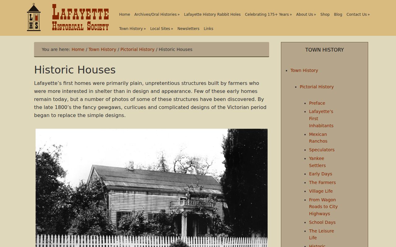
Historic-house notes are strongest when the named place, date, road form, and parcel evidence agree.
The Myth of a Lafayette Sanborn Run
No Lafayette-specific Library of Congress Sanborn title was located. That is a useful research boundary, not a reason to stop. Landownership and tax maps can identify historic parcels. City-layout maps, aerials, photographs, subdivision and survey maps can show changing geometry. Permits can date later work. Deeds can carry the legal description through a change in street number or APN. State the substitute used rather than calling one of these sources a Sanborn map.
When a former household disappears, close the trail through the Lafayette Cemetery record book, a local obituary, probate, and a later deed. The original 1874-era Death and Burial Record Book remains in the caretaker building, and the Historical Society holds a copy. It records name, death date, cause, age, and place of death. The County History Center adds obituary clippings, court and probate indexes, tax books, maps, and historical case material. Each endpoint answers a different question, so a death record should not be treated as proof of a deed transfer.
Lawful personal research. Address history belongs in family history, house history, estate work, and personal curiosity. Do not use names or addresses to stalk, harass, intimidate, or harm anyone; a lawful record does not make every use lawful.