
Lafayette ZIP Code Directory: 94549
The only verified Lafayette ZIP code is 94549. Its postal coverage includes incorporated Lafayette and postal addresses in unincorporated surroundings. That makes 94549 useful for checking a mailing address, but not sufficient for deciding whether a parcel sits inside the City of Lafayette. The official destination is written as LAFAYETTE CA 94549.
| ZIP | Areas Covered | Post Office | Notes |
|---|---|---|---|
| 94549 | Incorporated Lafayette and land beyond the city, including postal addresses in unincorporated surroundings | LAFAYETTE CA 94549 | Only verified Lafayette ZIP; city and postal lines differ |
No PO-box-only or unique ZIP was verified for Lafayette, and no split or realignment year was found in the authoritative research. Adjacent ZIPs are not added to the table merely because nearby services use them. The ZIP code directory therefore has one confirmed row and a clear warning about its reach.
Why Lafayette ZIP Code Reaches Beyond City Limits
A June 2015 City of Lafayette boundary map puts four outlines on the same sheet: the incorporated city, the sphere of influence, the school district, and ZIP 94549. The outlines do not match. The map is available through the official Lafayette boundary document and is the best local check against a simple postal assumption.
A sphere of influence is a possible future-jurisdiction planning area. It is not an annexation and does not turn an unincorporated address into a current City of Lafayette address. Greenhills and part of Saranap are the named local examples inside the sphere while remaining outside city government.
Boundary check. A 94549 mailing label can identify a postal destination without identifying the city custodian. Use the city or county jurisdiction that controls the record, not the postal name alone.
Greenhills and Saranap in Lafayette ZIP Geography
Greenhills and part of Saranap are named unincorporated surroundings within the Lafayette sphere of influence, and 94549 includes postal addresses beyond the city boundary. A person may use Lafayette in a postal address while a county office remains the custodian for land-use, building, assessment, or other records. That distinction matters when a ZIP search seems to point to the wrong public office.
The city line also differs from the school-district line shown on the 2015 map. A ZIP code directory can describe the postal reach, but it cannot assign a school boundary or establish civic membership. Those questions need the agency map or record designed for that purpose.
Search Lafayette ZIP Code Records
There is no verified Lafayette portal that returns a ZIP-wide resident or property roster. A sound ZIP code search is a handoff between postal validation and address-keyed records. Each step says what the source can prove and what it cannot.
- Check the mailing line. Enter the exact street address, city, and state in the USPS ZIP Code Lookup. Add the ZIP when validating a known address.
- Find the parcel. Use the address search in CCMAP, select the autocomplete result, and click the parcel to obtain its APN and map context.
- Move to the right custodian. The county Assessor counter or the recorder index may answer an ownership or deed question. Neither is a verified ZIP-wide resident filter.
- Handle voter data separately. California My Voter Status is an identity-matched self-service check, not a names-by-ZIP or names-by-street directory.
Once a ZIP narrows the geography, address-level work belongs in the Lafayette by-street directory. A street, APN, or legal description gives the next system a more stable key than the postal label.
Lafayette USPS Fields for a ZIP Code Search
The USPS form checks whether a precise address can be matched to a deliverable city, state, and ZIP combination. It does not look up an owner, a legal parcel, a city limit, a school boundary, or a voter precinct. The field set below keeps the postal step separate from the records step.
| Field or Control | Type | Required | Use for Lafayette |
|---|---|---|---|
| Street Address | Text | Yes in address mode | Enter the actual street line |
| Apt/Suite/Other | Text | No | Add a unit designator when one applies |
| City | Text | Yes | Use Lafayette when that is the USPS city line |
| State | Dropdown | Yes | Select CA |
| ZIP Code | Text | Optional or mode-dependent | Supply 94549 to validate a known result |
| Find | Button | Action | Return the standardized mailing result |
The successful USPS address lookup capture shows the form that supports this check.
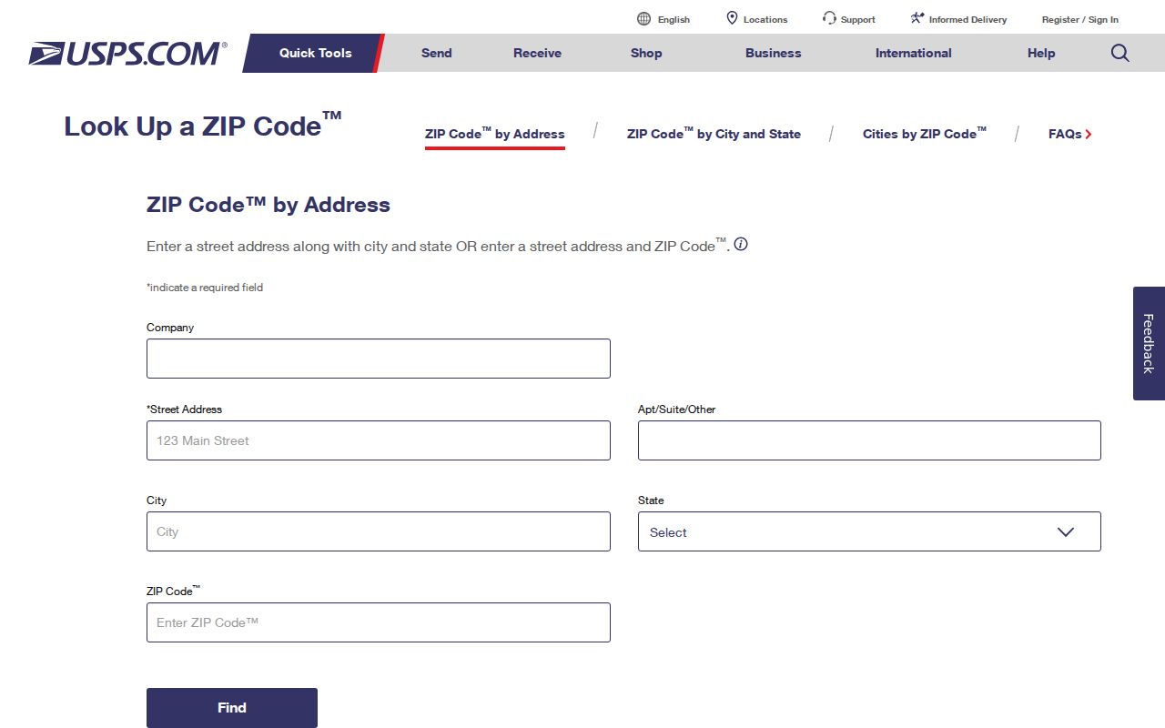
The USPS result confirms postal deliverability and the city-state-ZIP association. A match still needs a separate parcel or agency check before it is used to route a Lafayette record request.
What Lafayette Portals Do Not Return by ZIP Code
The Contra Costa Assessor's Maps and Property Information tools accept an address or APN through CCMAP and ParcelQuest Lite. Online results can show parcel geometry, situs information when assigned, building and lot details, assessed value, aerial context, and map links. Owner and mailing names are suppressed from the county web maps.
RecorderWorks searches by name, document number, book and page, recording date, document type, map, legal description, or parcel number. Accela uses address and permit groups. The voter status tool is identity matched. None of those verified paths accepts a ZIP and promises every person or property in it. The absence of a ZIP filter is a useful limit, not a missing step.
Lafayette Situs, APN, and Legal Description
A situs address is the location assigned to a parcel for property and map purposes. An APN is the assessor's parcel number. The research uses 155-280-015 only as an example of the nine-digit format. A legal description is the deed language that identifies the land through a recorded description, map, or related reference.
These keys answer different questions. USPS connects a mailing line to delivery. CCMAP connects an address to a parcel. The Assessor connects a selected parcel to public roll information at the counter. The recorder connects a named party to a recorded instrument. A legal description can preserve continuity when an address changes, a ZIP line is reassigned, or a parcel number changes after a split.
- Situs address
- The physical or property location used to find the parcel.
- APN
- A county assessment identifier that helps join a map to the roll.
- Mailing address
- A delivery address that may differ from the parcel's situs.
- Legal description
- Recorded land-identification language that carries more title weight than a postal label.
Lafayette ZIP Code Terms Explained
Postal terms describe delivery design, not who occupies a parcel or which government has jurisdiction. Keeping the terms distinct prevents a ZIP code directory from promising more than a postal system can supply.
- ZIP code
- A five-digit delivery area used by USPS to route mail. It is not a city-limit map.
- ZIP+4
- The five-digit ZIP plus four more digits that narrow delivery to a segment, building, or group of addresses.
- PO-box ZIP
- A ZIP used mainly for post-office boxes. It does not describe a normal street-resident area.
- Unique ZIP
- A ZIP assigned to one high-volume organization or destination rather than a broad neighborhood.
- Carrier route
- A delivery sequence or route grouping used by postal operations inside a ZIP.
No PO-box-only or unique Lafayette ZIP was verified. Those definitions belong in the vocabulary because a searcher may see them in national ZIP data, but they should not be used to pad the Lafayette table.
When Lafayette ZIP Lines Meet City Limits
The word Lafayette in a mailing address is not a legal finding about a parcel. The boundary map places ZIP 94549 beside the city limit, sphere, and school district so the differences can be seen at once. Census ZCTA 94549 is a block-based statistical approximation, not the USPS delivery boundary. The sphere describes possible future jurisdiction, not current city government. A county record can therefore be the right destination for an address that looks local in the postal line.
Use the custodian's boundary. City Clerk records belong to Lafayette when the city holds them. County assessment, building, recording, court, and other county records follow Contra Costa County jurisdiction. Postal geography helps find an address, then stops.
For municipal records, the Lafayette Open Government hub points to requests and disclosures. The correct office depends on the record and the government's jurisdiction, not on a ZIP directory row alone.
Historic Lafayette Names Beneath 94549
Modern ZIP searches can miss older evidence because Lafayette's records use older names. Research notes Brown's Mill, Brown's Corners, Centerville, and La Fayette. The official Lafayette name and post office were in use in the 1850s, while the village center shifted from Golden Gate Way and Second toward Mt. Diablo Boulevard and Moraga Road in the early 1860s.
Moraga Road was once called Commercial Street. Mt. Diablo Boulevard appears in an older description as the “Road from Oakland to Walnut Creek.” Try those variants in catalog, newspaper, map, and directory searches when a family or parcel disappears under the current address. These are search clues, not alternate ZIP codes.
Choose Lafayette or County Custody
A 94549 address can lead to different custodians. The Lafayette City Clerk handles municipal administrative and planning records at 3675 Mount Diablo Boulevard, Suite 210, Lafayette, California 94549, 925-284-1968. The Contra Costa County Assessor is at 2530 Arnold Drive, Suite 100, Martinez, and the county Clerk-Recorder is at 555 Escobar Street, Martinez.
For a ZIP code question, start with USPS. For a parcel question, start with CCMAP and the Assessor. For a recorded land document, use the county recorder's index. For city-held material, use the City's request route. The sequence keeps the Lafayette ZIP code directory useful without turning postal geography into a claim about a person's identity or a government's jurisdiction. It also leaves room for a records clerk to explain a boundary that an online map cannot settle.